SOUTHEASTERN N.C. — Overnight, Tropical Storm Debby came ashore for a second time near Bulls Bay, just north of Charleston in South Carolina.
READ MORE: ‘More rain than most of us see in a month’: Governor talks Debby, Biden issues disaster declaration
Now located 130 miles west of Wilmington, Debby’s lingering 5 miles-per-hour path is expected to pick up speed and weaken as she moves north-northeast through the Carolinas Thursday. It’s anticipated she will descend upon the central portion of the state Thursday evening.
In her wake, Debby, with sustained 50 miles per hour winds, has brought 4 to 7 inches of rainfall to the tri-county region in the last 24 hours. An expected 2 to 6 inches is anticipated, with some areas experiencing higher amounts.
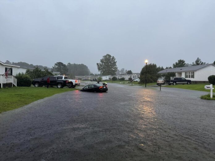
Flash-flood warnings have been in effect overnight, as pockets of heavy rain pour throughout the area. It’s led to at least one car being caught in rising waters in Leland in Brunswick County, according to town officials.
A Tesla had to be pulled by New Hanover County Fire and Rescue in the Kings Grant area, with the driver ably exiting to safety.
Pender County Emergency Management also noted they have made vehicular rescues.
Residents in Bladen County are under a flash-flood emergency, as roads to the town of Bladenboro have also been cut off by barricades to the rest of the county, as reported by WECT.
Motorists should remain off the roadways and avoid parking lots and streets that have rising waters. If driving, it’s advised to not pass through barricades; copious water, further compromised by heavy vehicles, can cause the asphalt to buckle, wash away or create sinkholes.
“Most flood deaths occur in vehicles,” the National Weather Service warned in its 5 a.m. update. “Stay away from storm drains, culverts, creeks, and streams. Water levels can rise rapidly and sweep you away.”
Throughout Thursday, more dangerous flooding can be anticipated in low-lying areas, places with poor drainage and near bodies of water. Squalls of rain are expected to continue upon Debby’s exit.
In downtown Wilmington, NWS reported early this morning a block of Water Street, facing the Cape Fear River, had some minor flooding, while across the river at the U.S.S. North Carolina, portions of Battleship Road were submerged.
The Northeast Cape Fear River is also flooding near Burgaw in Pender County. It’s at 15.3 feet, with areas nears Lanes Ferry on Highway 210 potentially flooded. As well, much of White Stocking Road is closed and the wildlife ramp on Shaw Highway is underwater.
A flood warning is in effect for the Northeast Cape Fear River at Chinquapin in Duplin County. Flooding takes place at 13 feet and the river is currently measuring 12, with water expected to rise above flood stage by late Thursday afternoon. This could impact nearby highways including Highways 41 and 50, plus I-40.
The river will continue rising and NWS now anticipates it will crest near 18 feet early Monday morning.
Wind gusts from 30-to-45 miles-per-hour — 55 in some beachfront towns — can be expected throughout Thursday, and hazardous marine conditions and seas continue to churn due to Debby. Mariners should alter plans and seek safe harbor.
Storm surge remains at 1 to 3 feet and people should avoid these areas, especially during high tide. Moderate beach erosion is possible.
A high surf and rip current advisory is in effect until midnight Friday. Waves could break 7 to 10 feet and surfers and swimmers are advised against entering the ocean.
The conditions remain favorable for tornadoes. Warnings were constant Wednesday, with video of one twister caught near the Pender and Sampson county border by Anthony Powell of the Harrells Fire Department. Just south of Wallace, NWS confirmed a tornado touched down at 2 p.m. at 1436 Bland School Road, damaging homes and causing a building to collapse, according to WRAL.
All cellphones and screens should stay charged for access to potential warnings and emergency help, if needed. Also, it’s important to identify a safe room or space in the home to take shelter, in the event of a tornado warning.
Tips or comments? Email info@localdailymedia.com.
Want to read more from PCD? Subscribe now and then sign up for our morning newsletter, Wilmington Wire, and get the headlines delivered to your inbox every morning.
