RALEIGH, N.C. (WNCN) — Despite a small dusting of snow earlier this month west of the Triangle, the Raleigh area has been 1,067 days without snow.
So will we break that snow drought in the winter of 2025? We’ll see.
2024 ended as the hottest year on record in Raleigh, but 2025 will kick off with some of the coldest air we’ve seen yet this season.

JANUARY 2025
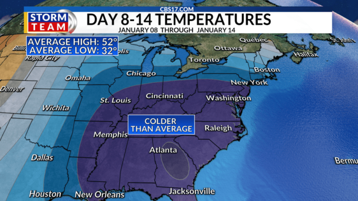
The Climate Prediction Center predicts well below-average temperatures as far south as Florida through January 13th. The pattern shift will be favorable for some wintry weather in the southeast, but we’ll see if all things align just right for snow lovers in central North Carolina.
There is high confidence that an Arctic outbreak will spread from the northern Plains to the south and east. Frozen precipitation is expected across the southern Plains and heavy snow along much of the Appalachians, the Ohio Valley, the Mid-Atlantic, the Great Lakes, and the Northeast — possibly leading to significant travel disruptions into the new year.
The Climate Prediction Center is forecasting a drier-than-average period at the same time as that arctic air settles south.

WHAT TO EXPECT IN 2025
The first weekend of 2025 will be frigid and in the 40s. Mornings will be in the 20s and 30s. An area of low pressure will pull northeast next Monday, January 6, bringing mainly chilly rain to central North Carolina.
However, some models, including the American and European models hint that ice or snow could be possible, but the track of the storm system will be key to determining who sees and gets what.

Models still bring in plenty of chilly rain to central North Carolina on Monday, however, tracks differ. The farther north the low-pressure tracks, the lower the chance for snow in the Triangle.
As of Wednesday morning, the European Model showed a more northern track, which would mean a chilly rain. The American Model tracks next Monday’s weather maker a little further south, bringing the chance of a wintry mix here in central North Carolina. While it’s too early to nail down exactly who will see and get what on Monday, the likely scenario right now is a chilly rain over the Triangle and a mix in northern North Carolina and southern Virginia.
The map below will shift around as the track shifts around.

By Friday, we’ll know more about what to expect next week.


