RALEIGH, N.C. (WNCN) — With Wednesday’s winter storm, the Triangle got its third snow day of 2025.
While some parts of central North Carolina got soft snow, others got sleet and freezing rain. In many places, the winter precipitation eventually turned to slush and ice later in the night.
So how many inches of snow accumulated in different places across the region?

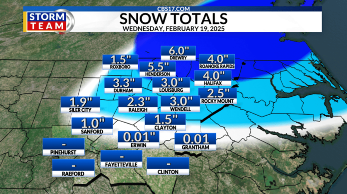
Here are the preliminary snow totals as of 11 p.m. Wednesday night:
| LOCATION | COUNTY | SNOW TOTAL IN INCHES |
| Henderson | Vance | 5.5 |
| Oxford | Granville | 5.0 |
| Drewry | Vance/Warren | 5.0 |
| Roanoke Rapids | Halifax | 4.0 |
| Durham | Durham | 3.8 |
| Youngsville | Franklin | 3.5 |
| Halifax | Halifax | 3.5 |
| Chapel Hill | Orange | 3.0 |
| Creedmoor | Granville | 3.0 |
| Wendell | Wake | 3.0 |
| Carrboro | Orange | 2.6 |
| Cary | Wake | 2.5 |
| Apex | Wake | 2.5 |
| Fuquay-Varina | Wake | 2.5 |
| Rocky Mount | Nash/Edgecombe | 2.5 |
| RDU Airport | Wake/Durham | 2.0 |
| Harnett County | Harnett | 2.0 |
| Tarboro | Edgecombe | 2.0 |
| Siler City | Chatham | 1.9 |
| Clayton | Johnston | 1.5 |
| Bethel Hill | Person | 1.5 |


