


Forecasts suggest the 2025 Atlantic hurricane season may be slightly above average due to ENSO transitioning to neutral and warm sea temperatures.
CHARLOTTE, N.C. — The 2025 Atlantic hurricane season hasn’t even begun but forecasts are suggesting it will be typical to slightly above average.
The main basis for this is the status of the ENSO cycle (El Niño-Southern Oscillation). The ENSO Cycle is transitioning from a weak La Niña to a neutral phase known as La Nada. This is also coupled with warmer Atlantic sea surface temperatures. Colorado State University (CSU) and North Carolina State University (NC State) both predict heightened activity, though their models differ slightly in scope.
ENSO neutral conditions and hurricane activity
The ENSO cycle-which alternates between El Niño (warmer Pacific waters) and La Niña (cooler Pacific waters) is now as of May 2025 in a neutral phase (“La Nada”). This phase reduces wind shear in the Atlantic, creating favorable conditions for tropical storm development.
While La Niña conditions persisted through March 2025. we will start the season in the La Nada phase in June. Historical data shows neutral or La Niña phases correlate with more active Atlantic hurricane seasons due to reduced vertical wind shear.

Notable hurricane seasons while in a “La Nada” phase
-
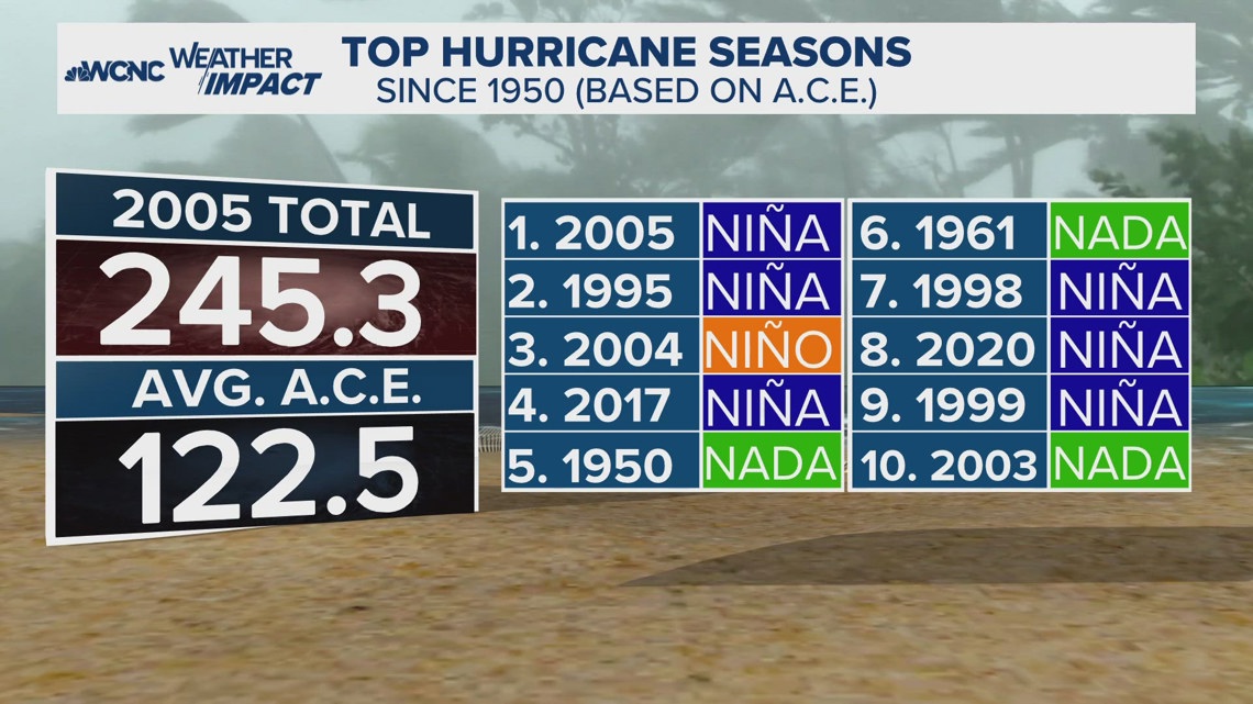
2005: The most active season on record, with 28 named storms, occurred during ENSO-neutral conditions before transitioning into a La Niña after Katrina. This season spawned five Category 5 hurricanes. Despite neutral ENSO, exceptionally warm Atlantic waters fueled rapid intensification.
-
1992: Hurricane Andrew, one of the strongest U.S. landfalls, struck during a neutral phase. This season demonstrated that even low storm counts can produce catastrophic events. Proving it only takes just one.
-
2019: Highlighted the unpredictability of neutral phases, as Hurricane Dorian’s extreme intensity contrasted with otherwise moderate seasonal activity. Dorian was also one of the slowest moving storms which at one point was stationary as a Category 5 hurricane.
Forecast highlights
Colorado State University 2025 predictions:
-
17 named storms (average: 14.4)
-
9 hurricanes (average: 7.2), with 4 major hurricanes (Category 3+).
-
155% of average Accumulated Cyclone Energy (ACE), indicating higher intensity and longevity
North Carolina State University 2025 predictions:
Both institutions emphasize the role of above-average Atlantic sea surface temperatures-though slightly cooler than 2024-as a critical fuel source for storm formation. CSU’s models also highlight similarities to active seasons like 2017 and 20207.
Regional Risks and Preparedness
-
The U.S. East Coast, Gulf Coast, and Caribbean face above-average landfall probabilities.
-
Rapid intensification is a concern due to high ocean heat content.
As a reminder, it only takes one storm. So the overall A.C.E. or number of storms doesn’t matter. It matters if that named storm makes landfall. And even a tropical storm can lead to devastation and loss of life from its rain alone.
Contact Chris Mulcahy at cmulcahy@wcnc.com and follow him on Facebook, X, Instagram and TikTok.
