Updated at 12:50 p.m. ET
A tropical storm warning is in effect for the North Carolina coast on Wednesday due to Hurricane Idalia.
The National Weather Service says the storm will also bring heavy rain and winds to the Triangle on Thursday. Some places south of Raleigh can expect wind gusts of up to 40 mph at times. Areas south of Raleigh could also see two-to-five inches of rain and potential flooding.
“When it passes south of the Triangle, it’s forecast to be a tropical storm. And we want to remind folks that you never want to drive through areas where water covers the road,” said Nick Petro, a meteorologist with the National Weather Service in Raleigh. “We have a saying here: Turn around, don’t drown.”
Petro says other tips include having storm kits with flashlights and first aid supplies inside. He adds there could be downed trees and power outages.
Here’s the latest on impacts from Hurricane #Idalia in central #NCwx. 2-5″ of rain (locally 5-7″) is expected to the south & east of Raleigh, which may cause flash flooding. Wind gusts of 30-45 mph may also cause scattered downed trees & power outages, especially in the far SE. pic.twitter.com/PE6ahK0v8K
— NWS Raleigh (@NWSRaleigh) August 30, 2023
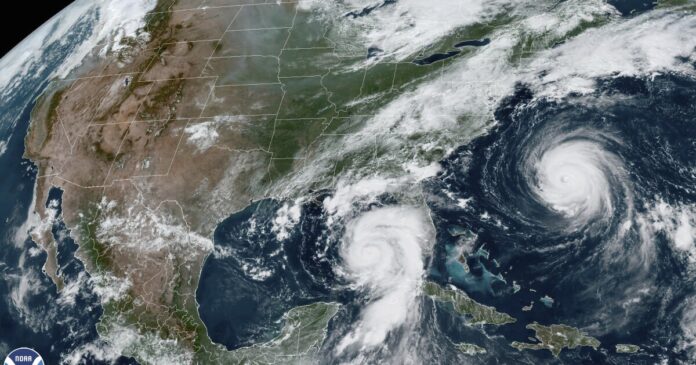
Hurricane Idalia made landfall on Florida’s west coast on Wednesday morning as a Category 3 storm. More than 200,000 customers were without power in the state. The National Weather Service in Tallahassee called Idalia “an unprecedented event” because no major hurricanes have hit the Big Bend — where Florida’s peninsula merges with the panhandle — since 1950, according to the Washington Post.
Idalia is expected to become a tropical storm by the time it reaches the Carolinas. North Carolina Gov. Roy Cooper, South Carolina Gov. Henry McMaster, and Georgia Gov. Brian Kemp have already announced states of emergency.
“We think that this storm will affect North Carolina, not at hurricane strength, but we do believe we will see strong winds and power outages and a lot of rain, particularly in the southeastern part of the state,” Cooper said Tuesday. “I had a discussion this weekend with the Commissioner of Agriculture about farmers deeply concerned about getting crops out of the field and agricultural products out of the field. That is why I have issued a state of emergency, in order to suspend the regulations on the highway so the farmers can take more out of the field.”
Meanwhile, Hurricane Franklin — which was a Category 2 storm Wednesday morning — is expected to affect the North Carolina coastline through rip currents this week. Franklin was about 200 miles west of Bermuda around 5 a.m. Wednesday.
The combinations of effects from Franklin and Idalia could create the chance for extreme weather or possible tropical storm conditions as far west as Durham, according to the New York Times.
Public schools in Pender, Dare, Bladen and Robeson counties have already announced that they will be closed on Thursday, and Robeson County schools asked parents to be prepared for the possibility of an early dismissal on Wednesday. Dare and Bladen counties will have remote learning on Thursday.
The National Weather Service in Morehead City says that eastern North Carolina could start feel the impacts from Idalia beginning Wednesday evening with the chance of tornado threats and coastal flooding.
A flood watch will go into effect around 2 p.m. for most of central North Carolina and the Triangle area due to Hurricane Idalia.
“Some of the portions towards the Sandhills… There’s some areas that are expected to get maybe seven inches of rain. And so those areas have the potential for flash flooding and potentially some river flooding,” said Andrew Kren of the National Weather Service in Raleigh.
Rainfall south and east of Raleigh is expected to get up to five inches, and up to two inches around the Triangle. Kren says to always have extra batteries and first aid kits in case of an emergency or power loss.
