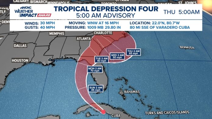
PTC Four was upgraded to a tropical depression Saturday morning. Here’s the latest breakdown of the storm’s likely impacts to the Carolinas.
CHARLOTTE, N.C. — Florida, Georgia and the Carolinas could see impacts in the days ahead from what is currently known as Potential Tropical Cyclone Four.
PTC Four will likely become a tropical depression later Friday and eventually get a name on Saturday. The given name will be Debby, making it the fourth storm of the 2024 Atlantic hurricane season.
What is a Potential Tropical Cyclone
Before a storm officially forms, the National Hurricane Center can dub these tropical disturbances as “potential tropical cyclones.” This classification allows NOAA to begin initiating watches and warnings to people.
RAISE YOUR WEATHER IQ: Understanding the stages of hurricane development
NOAA began using this classification for this future storm system starting at 11 a.m. on Friday.
U.S. landfall
Tropical systems take the path of least resistance. With the positioning of a high-pressure system to the west combined with a cold front to the north, Potential Tropical Four could move perfectly over Florida, skirt Georgia and the coastal Carolinas, before eventually heading out to sea.
The frontal boundary is what is expected to block PTC Four from moving further inland. This will spare the Charlotte and inland Carolinas from experiencing higher impacts.
By this weekend, impacts will begin for the Gulf Coast side of Florida. These impacts are expected to be heavy rain, near tropical-storm force winds, and minor storm surge.
The storm is then expected to move inland over north-central Florida before skirting Georgia’s Atlantic coast on Monday.
Carolina impacts
For the Carolinas, almost all the anticipated impacts from this storm will be along the coast. While the coast could see heavier rains and gustier winds, Charlotte can anticipate limited impacts in the form of increased cloud cover and increased rain chances.
Impacts from this storm in the Carolinas could be seen Monday and Tuesday.


Rain totals
Over the next seven days, inland communities near Charlotte will see between one-and-a-half and two-and-a-half inches of rain. There may be slightly higher totals east and southeast of Charlotte including in communities such as Anson, Richmond and Chesterfield counties. In those areas, they could see as much as between three and four inches of rain.
The highest rainfall totals will be along the Carolina coast including in locations such as Charleston, Myrtle Beach, Wilmington and the Outer Banks. Coastal locations could see as much as 7 inches of rain. These impacts could result in localized flooding and minor storm surge for Carolina’s coastal communities.
Often times when a tropical systems skirts the coast, residents can expect beach erosion, dangerous surf and boating conditions, and elevated wave heights.
Wind speeds
Wind gusts will be slightly elevated across the Charlotte area. On Monday and Tuesday, winds could gust as high as 20 mph. Again, these impacts are very minor.
RAISE YOUR WEATHER IQ: Brad Panovich explains the Beaufort Wind Scale
Tropical-Storm-Force Wind Arrival Time
Between Monday and Wednesday along the coast, the highest wind gusts could peak between 35 and 55 mph. Due to the way the Outer Banks juts out into the Atlantic and thus may be close to the storm’s center of circulation, wind gusts there could approach 65+ mph.
WCNC Charlotte’s Weather IQ YouTube channel gives detailed explainers from the WCNC Weather Impact Team meteorologists to help you learn and understand weather, climate and science. Watch previous stories where you can raise your Weather IQ in the YouTube playlist.


