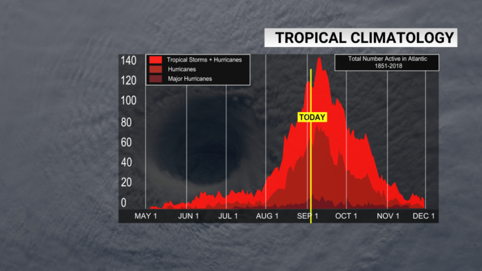
(WGHP) – We’re one week out from the peak of hurricane season, Sept. 10, and after a quiet few weeks, the tropics are heating back up.
The National Hurricane Center has cited three areas of interest in the Atlantic, two of which have a moderate chance for development and one with a low chance for development in the next week.
Caribbean Sea
The first tropical wave is an area of disorganized showers and thunderstorms located just south of the Dominican Republic, over the central Caribbean Sea.
While this wave is in the warm Caribbean waters, the chance for development is low over the next couple of days. The system is expected to move westward towards the Yucatan Peninsula through the end of the week.
According to the National Hurricane Center, once the tropical wave is located in the western Caribbean and southwestern Gulf of Mexico, conditions will be more favorable and a tropical depression could form by late this week or over the weekend.
Eastern Atlantic Ocean
A second tropical wave is fresh off the coast of Africa in the eastern Atlantic and is currently just an area of disorganized showers and thunderstorms.
As the system pushes northwestward, it may bring heavy rain and gusty winds to portions of the Cabo Verde Islands in the next couple of days.
Not only could it impact the Cabo Verde Islands, its movement over the eastern Atlantic will also bring this system into a more conducive environment for development, meaning another tropical depression may form by the end of the week.
Central Atlantic Ocean
The tropical wave with the lowest chance for development as of Sept. 3 is located between the west coast of Africa and the Lesser Antilles. It’s also located in between the other two tropical waves.
The disorganized area of showers and thunderstorms could have some slow development as it moves west-northwestward in the next couple of days. However, by the weekend, it’s expected to be located in an area of the Atlantic with unfavorable conditions for the development of a tropical system (i.e. wind shear or dry air).
2024 Atlantic Hurricane Season So Far…
As of Sept. 1, the 2024 season has seen five named storms, three of which reached hurricane strength with one major hurricane.
The one major hurricane, Beryl, was the earliest Category 5 hurricane on record.
Before hurricane season began, NOAA predicted an 85% chance of an above-average season, forecasting a range of 17 to 25 named storms, 8 to 13 of which reaching hurricane strength and 4 to 7 reaching major hurricane strength.
For us to be considered “on track” for NOAA’s forecast, we would need to have averaged around 8.5 to 12.5 named storms with 4 to 6.5 hurricanes and 2 to 3.5 major hurricanes through Sept. 1, so we are slightly behind schedule compared to NOAA’s original forecast.
If we look at the season-to-date normal through Sept. 1, the rate at which we’re seeing tropical cyclones form is behind schedule but we’re ahead of schedule when looking at the strength of the storms.
If no additional development occurs before Sept. 7, the season will be considered “normal” for all three categories: named storms, hurricanes and major hurricanes.
