


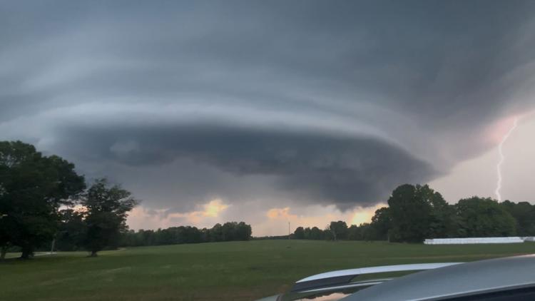
A supercell thunderstorm loomed over York County Tuesday, impressively captured in a dramatic drone photo by Kari Smith.
ROCK HILL, S.C. — On Tuesday evening, a towering, rotating thunderstorm known as a supercell was seen in York County. A WCNC Charlotte viewer, Kari Smith, sent stunning drone photos of the storm to Chief Meteorologist Brad Panovich. Smith’s husband captured the images over Highway 324 in Rock Hill.
The photo revealed a massive, layered cloud base that truly looked like something out of a sci-fi movie.
And Smtih wasn’t alone. Across the area, photos were snapped of the “mothership,” the nickname associated with this type of storm because it resembles a spacecraft.
But what exactly is a supercell, and how can you spot one in the sky?
Supercell thunderstorm produces “mothership” cloud
The Science Behind Supercells and Mesocyclones
Supercells are the least common type of thunderstorm. They are known for producing severe weather like large hail, damaging winds, and sometimes tornadoes. What sets them apart from other storms is their rotating updraft, known as a mesocyclone. This rotation is key to the supercell’s structure and strength.
-
Wind Shear – Supercells need strong wind shear, or a change in wind speed and direction with height. This creates horizontal rotation in the atmosphere and the tilt of the storm.
-
Lift and Instability – Rising warm, moist air begins to tilt that horizontal spin vertically, forming the rotating updraft (mesocyclone).
-
Rotation Aloft – As the storm matures, the mesocyclone becomes organized and powerful, sometimes leading to severe weather conditions below.
Despite their menacing appearance, not all supercells produce tornadoes. In the case of Tuesday’s storm, although the structure was rotating, the rotation stayed aloft — no tornado touched down. However, these storms can still bring damaging winds, large hail, and intense lightning.
The “Mothership” Appearance
The “mothership” nickname comes from the storm’s visually dramatic shape — a large, round, layered base that seems to hover ominously over the landscape. This appearance typically means that the storm is highly organized and that rotation is occurring within the cloud base.
In the photos taken, you can clearly see the spiraling structure of the mesocyclone.
How to Spot a Supercell in the Sky
If you’re out and about and curious whether that ominous storm cloud could be a supercell, here are a few things to look for:
-
A dark, flat cloud base with a clear, often rounded lowering in the center.
-
Visible rotation — sometimes you can actually see the storm turning.
-
A stacked or layered appearance, especially near the base — like a flying saucer.
-
Strong inflow winds, often pulling warm, moist air into the storm.
-
A persistent, isolated structure — supercells often stand out from other thunderstorms.
Remember, even if a supercell isn’t producing a tornado, it can still be dangerous.
Contact Bekah Birdsall at rbirdsall@wcnc.com and follow her on Facebook, X and Instagram.
