


Heavy rainfall threatens cities in the Carolinas with flash flooding as additional rain is forecast.
CHARLOTTE, N.C. — Less than 24 hours into a multi-day rain event, some cities in North Carolina and South Carolina have already seen an inch of rainfall. A flash flooding threat remains because more rain is on the way.
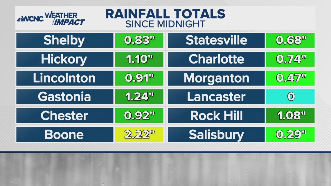
Between 12 a.m. and 4 p.m. on Monday, the following rainfall totals were measured:
- Boone: 2.22″
- Gastonia: 1.24″
- Hickory: 1.10″
- Rock Hill: 1.08″
- Lincolnton: 0.91″
- Chester: 0.87″
- Shelby: 0.83″
- Charlotte: 0.74″
- Statesville: 0.68″
- Morganton: 0.47″
- Salisbury: 0.29″
An estimate for Lancaster was not immediately available.

Monday was just the first day of three where at least some rain is forecast. With more rain on the way, here is how much additional rain could fall through Tuesday:
- Lincolnton: 1.97″
- Salisbury: 1.75″
- Hickory: 1.30″
- Boone: 0.84″
- Gastonia: 0.82″
- Morganton: 0.59″
- Shelby: 0.48″
- Statesville: 0.45″
- Charlotte: 0.43″
- Chester: 0.41″
- Rock Hill: 0.28″
WCNC Charlotte’s Weather Impact Team wants everyone in the Charlotte area to be weather alert on Monday due to the widespread, heavy rain. The flash flooding risk continues on Tuesday and Wednesday but becomes more isolated than the threat on Monday.
Widespread rain moved in Sunday night and continues through Monday. Showers become more spotty on Tuesday and Wednesday, but downpours are still possible.
