


The U.S. government is scaling back weather balloon launches. Here is why a weather balloon is such an important tool for weather forecasting.
CHARLOTTE, N.C. — A behind-the-scenes tool in weather forecasting is quietly being scaled back as the U.S. government is cutting back on weather balloon launches. Several National Weather Service (NWS) sites have limited their launches due to staffing cuts.
Experts and our meteorologists at WCNC Charlotte say this could hurt the accuracy of forecasts. But what is the purpose of these weather balloons? Chris Mulcahy explains.
The weather balloon
The National Weather Service has been launching balloons since 1930. Now, balloons are launched twice a day at over 91 sites everyday. For example, Charleston’s NWS office launches a weather balloon at 7 a.m. and 7 p.m. every day.
A weather balloon reads the atmospheric conditions up to 10 to 20 miles high in the lower troposphere (lowest level of the atmosphere).
A weather balloon is huge — up to six feet in diameter. Attached to it is a radiosonde that reads and observes temperature, wind, relative humidity, dew point, and pressure above the ground. This radiosonde is tracked by specialized equipment that is fed the data as the balloon rises.
As the balloon rises, it expands. It can expand up to four times (20-25 feet in diameter) its size before eventually popping around 90,000-100,000 feet. The total flight takes around two hours and can drift over 100 miles away from the launch site.
Radiosonde observations are used for several purposes, including:
- Input for computer-based weather prediction models.
- Local severe storm, aviation, and marine forecasts.
- Weather and climate change research.
- Input for air pollution research.
- Ground truth for satellite data.
What the data looks like
This is advanced meteorology, but this chart below is an upper air sounding. The technical name is a Skew-T/LogP Diagram.

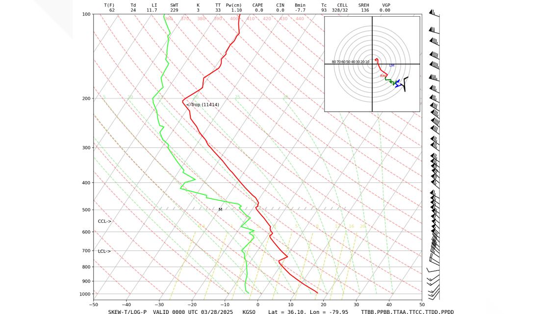
The most important use of these diagrams comes when severe weather is looming.
When the atmosphere is especially primed, a third weather balloon launch will likely happen around 1-2 p.m. to ready meteorologist with up-to-date data before the event starts to pop. Also following the red line, if it is completely below 0 (°C) then snow is likely. This is also where the term ‘warm nose’ comes from when talking about a wintry mix,
These diagrams from technical analysis can:
- Show how unstable the atmosphere is (measuring the available potential energy – C.A.P.E.).
- Show the degree of wind shear and how much a storm could potentially rotate.
- See if there is an inversion which could inhibit storms from popping.
- Define the precipitation type.
In conclusion
Especially in places where severe storms often form or during the beginning and end of winter when ice events are most likely, these weather balloons are vital.
That could mean less reliable forecasts.
Experts say weather balloons provide some of the most important data for predicting what’s coming next. Without them, forecasters may be left guessing. And even small changes in forecast accuracy can create big risks during dangerous storms. Some private companies are stepping in to help. But scientists warn — nothing can fully replace what the government system provides.
Contact Chris Mulcahy at cmulcahy@wcnc.com and follow him on Facebook, X, Instagram and TikTok.
