(NEXSTAR) – If you’re one of the millions of Americans thawing out after a week of Arctic air and deep freezes, spring weather and sunshine can’t come soon enough. On Thursday, national forecasters gave us a sneak peek at the warmer season to come.
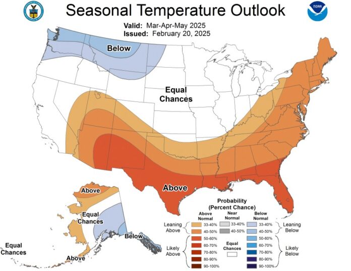
The seasonal outlook, put together by NOAA’s Climate Prediction Center, gives a broad overview of the temperature and precipitation patterns we can expect to see around the country between March and May.
It’s good news for some folks sick of the cold – many states are favored to see a warmer-than-average spring season. The southernmost states (who admittedly haven’t been suffering the most from a frigid winter) have the best odds of seeing unseasonably warm temperatures over the next three months.
It’s the opposite for the Pacific Northwest, which is leaning toward a cooler-than-normal spring. The middle stretch of the country, shaded in white, has equal chances of seeing one of three outcomes: a cold spring, a warm spring, or a normal spring.

The warmth down South will likely be paired with a dry weather pattern, the outlook says. The Southwestern states and Florida are leaning toward seeing below-average precipitation between March and May.
Those regions are already experiencing some degree of drought, according to the U.S. Drought Monitor, so a dry season would further strain those states’ water stores.
Wetter weather is in the forecast for the Pacific Northwest, Great Lakes and Ohio Valley this spring. That pattern is consistent with the La Niña phenomenon we’re currently seeing.

If you’re reading this from a city or state that’s still quite cold this week, you won’t have to wait until spring for the first bit of relief to arrive. Thursday was expected to be the “last truly cold day” across the country as temperatures rise next week, Weather Prediction Center meteorologist Scott Kleebauer said
An arctic air mass brought widespread, record-breaking cold to the central United States, and some locations in the Plains and Lower Mississippi Valley experienced their coldest temperatures on record this late in the season, according to the Weather Prediction Center.
In Nebraska, Grand Island set a new record for Feb. 20 of minus 24 Fahrenheit , breaking the old record of minus 11 F set in 1938, while Hastings set a new record of minus 20 F, eclipsing the record of minus 12 F in 1918.
In Missouri, new record lows were set in several cities, including Springfield at minus 12 F, breaking the record of 7 F in 1918, and Joplin at minus 9 F, breaking the record low of 16 F in 1963, 1978 and 2021.
Unusually heavy snow also led to hundreds of vehicle crashes in Virginia and North Carolina.
The Associated Press contributed to this report.


