La Niña returns, and that’s not good news for snow lovers.
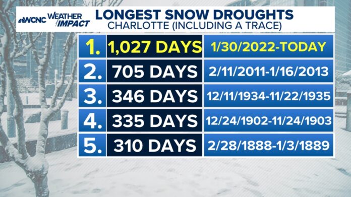
CHARLOTTE, N.C. — As of Nov. 21, 2023, Charlotte has gone 1,028 days with zero snow. This is by far the longest snow drought in the city’s history, and it includes two snowless seasons in the past two years, both of which were firsts for Charlotte.
So, can we break this drought this year? Here’s a look at the ingredients that go into this year’s winter forecast.
La Niña returns
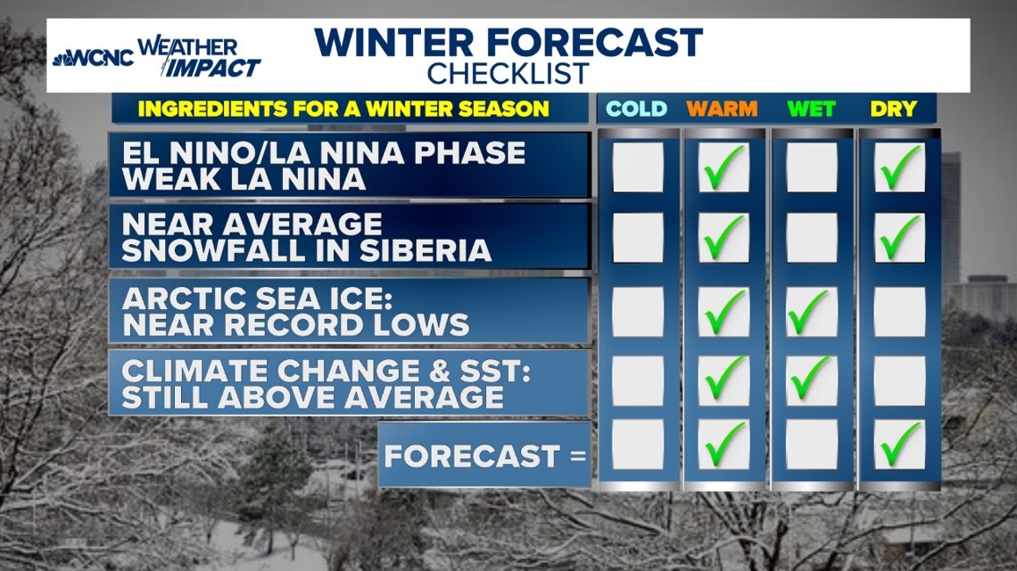
La Niña, characterized by cooler-than-average sea surface temperatures in the central and eastern equatorial Pacific, significantly impacts winter weather patterns in the Carolinas. We had three straight winters with La Niña before last year’s El Niño pattern.
Here’s what you can expect:
-
Warmer and drier conditions: La Niña typically brings warmer and drier winters to the Southeast, including the Carolinas, with less precipitation.
-
Reduced snowfall: With drier conditions, snowfall is generally below average. For instance, the Triangle area in North Carolina has experienced winters with little to no snow during La Niña years.
-
Increased drought risk: The lack of precipitation can lead to drought conditions. This has been observed in past La Niña winters, where rainfall was significantly below average, leading to drought declarations.
-
Occasional cold spells: While overall temperatures are warmer, La Niña does not rule out the possibility of occasional cold spells or frost, especially in the northern parts of the Carolinas.

Snowfall in Siberia in October
The amount of snowfall in Siberia during October can indeed influence winter weather patterns on the East Coast of the U.S. Here’s how:
-
Snow cover and the polar vortex: When Siberia experiences near-average snowfall in October, it can affect the strength and position of the polar vortex. The polar vortex is a large area of low-pressure and cold air surrounding the poles. Increased snow cover in Siberia can lead to a stronger and more stable polar vortex, which tends to keep cold air locked up in the Arctic.
-
Arctic Oscillation (AO): The Arctic Oscillation is a climate pattern characterized by winds circulating counterclockwise around the Arctic at around 55 degrees north latitude. When Siberian snow cover is near average, the AO can remain in a neutral or slightly positive phase, leading to milder winter conditions on the East Coast.
-
Cold air outbreaks: Despite the general trend towards milder winters, near-average snowfall in Siberia does not eliminate the possibility of cold air outbreaks. These can still occur if the polar vortex weakens or shifts, allowing cold Arctic air to spill southward into the U.S.
While near-average snowfall in Siberia can contribute to a more stable polar vortex and milder winter conditions on the East Coast, it doesn’t rule out the chance of occasional cold spells.

Warm ocean temperatures again
Above-average sea surface temperatures (SSTs) can significantly impact winter weather in the Carolinas. This, combined with a warming climate, is the main cause of our snowfall and cold trending down over time in the winter here in the Carolinas.
-
Warmer temperatures: Warmer SSTs often lead to warmer winter temperatures in the Carolinas. This is because the ocean releases more heat into the atmosphere, which can raise air temperatures.
-
Increased precipitation: Warmer SSTs can enhance evaporation, leading to more moisture in the atmosphere. This can result in increased precipitation, including rain and, occasionally, snow.
-
Storm activity: Warmer SSTs can also influence storm tracks and intensity. For example, they can lead to more frequent and intense coastal storms, which can bring heavy rainfall and strong winds to the region.
-
Drought conditions: On the flip side, if the warmer SSTs are part of a broader climate pattern like La Niña, the Carolinas might experience drier conditions. La Niña typically shifts the jet stream northward, leading to less precipitation in the Southeast.

Overall forecast: Warm and dry
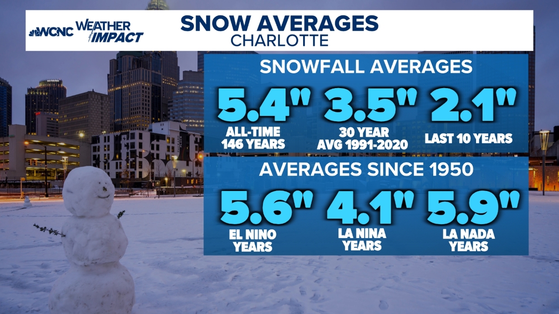
We have only had an above-average snowfall in five out of the past 20 years, and the trends aren’t looking higher right now.
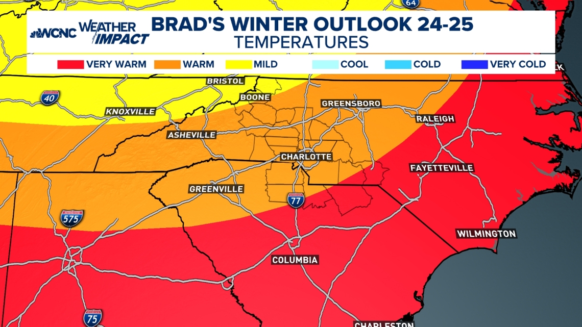
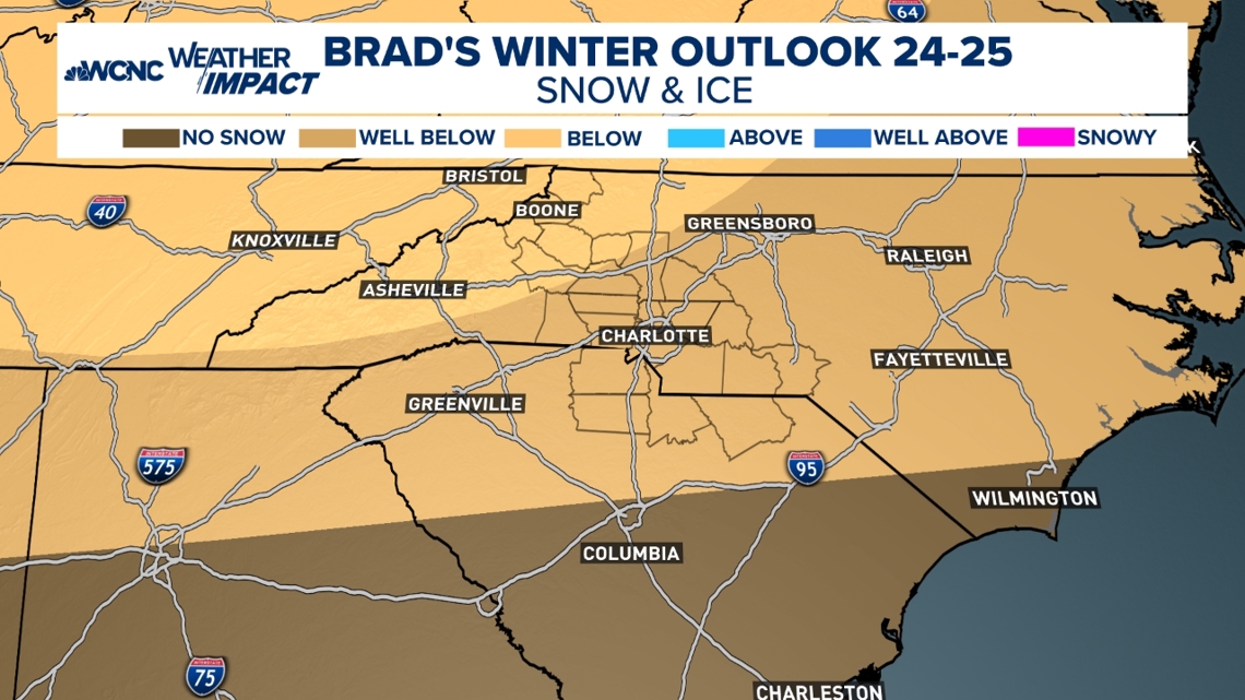
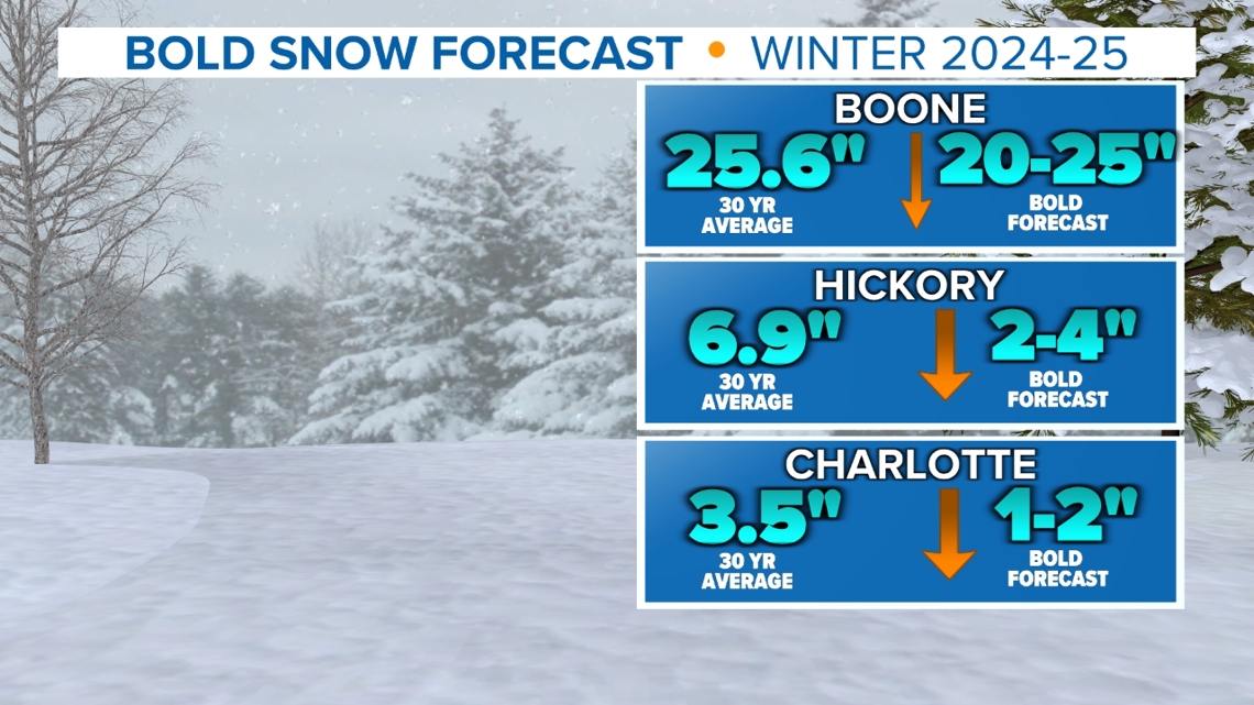
The combination of the La Niña, warm water, and below-average arctic sea ice just keeps moving cold air sources for the region. At the same time, I see us having a mild to warm winter with below-average snowfall again. I do think we will break the snow drought this year with 1 to 2 inches of snow at some point this winter. Our averages for snowfall are so low it honestly only takes one good storm to give us above-average snowfall.
Even if the rest of the winter is warm and dry, take a look at the forecast in maps with this gallery.


Contact Brad Panovich at bpanovich@wcnc.com or follow him on Facebook, X and Instagram.


